Post by iconPost by Ursus Maritimus | 2018-01-22 | 17:40:42

ready for subscription, no buoys

commenticon 70 Comments
Post by iconPost by Lasse | 2018-01-22 | 17:43:44
This looks really fun! Lots of alternative routes I guess. :-)

Or??
Post by iconPost by bewareth | 2018-01-28 | 15:15:07
there are 2 boys to pass so, there goes the many options in routes to follow.

Post by iconPost by zezo | 2018-01-22 | 17:49:43
They've also raised the race level from 5 to 4, with a price increase from 10 to 15 accordingly.
Post by iconPost by marcusbelgicus | 2018-01-22 | 17:55:50
Same level than the leg between Cape town and Freemantle!
Post by iconPost by Gufmiester | 2018-01-23 | 08:53:02
It’s Fremantle (not in Austria). But better not stop picking up spelling mistakes especially not on the French site
Post by iconPost by zezo | 2018-01-22 | 21:22:42
Looks like the main choice is left or right of PNG. The boat is not fast enough to go further East than that.

But there may be a cyclone developing in the Philippine sea in a week, and the outlook may be quite different from the current one.
Post by iconPost by Ursus Maritimus | 2018-01-22 | 22:00:45
can you add a map for it? or do you do that when leg 6 is closed officially (24/1) ?

Post by iconPost by YourMomSA | 2018-01-22 | 22:44:00
There could also be some question of whether to go above, below, or through the Philippines.

How good is the router at considering options through the Philippines? I have a rough sense that it might avoid those routes in favor of more open water. If a good route existed through there, would it show it?

Post by iconPost by Ursus Maritimus | 2018-01-23 | 13:05:38
would be nice to be able to 'force' routing options, such a north of Philippines, e.g. by means of routing-waypoints
Post by iconPost by YourMomSA | 2018-01-23 | 13:59:12
You can do a bit of forcing, by moving your start and finish places around to establish a route that would pass through the desired area at the desired time. Usually if it's impossible to find a route that would do so because the router is willing to go way out of its way to avoid the area, then that means the area isn't a viable option. The reason I asked this question was because I was trying to do that a bit with the Philippines. I tried setting destinations just to the West of the middle of the Philippines, and it refused to route through the Philippines to get there. It wanted to go around to the north or the south. This means either that the routes through the middle are so awful that it's better to go around even if your destination isn't far away... or that the router is having trouble assessing those options.
Post by iconPost by WildWassa | 2018-01-23 | 15:57:20
If a Skipper had chosen a good route in the VOR4, Melbourne/Hong Kong leg, would that route be suitable again, if the winds are favourable?

I noticed Skippers who were doing well early-on in the VOR, on the western routes, getting bogged down in the islands and losing their good leads, to the Skippers who went east and then headed well north to the open seas, before then heading west to Hong Kong. Sanya isn't too far SW of Hong Kong.

Does the minimum 4kt winds in the islands favour the Clipper with the Clippers lower top speed? Making going through the myriad of islands west of New Guinea less of a handicap?


Post by iconPost by YourMomSA | 2018-01-23 | 16:23:46
The starting location in this case changes things. Coming from Whitsundays, sailing as far East as the Volvo leg winners went is unlikely to pay off (although that doesn't mean it can't).

The 4-kt minimum windspeed definitely makes it easier to get through routes that real-life boats would never try. I'm not sure if they help Clippers more than other boats or not, though. With the 4-kt minimum windspeed, it becomes more about wind angle than wind speed.

One big difference between Clippers and Volvos is how they perform upwind versus downwind. Both boats are better downwind than upwind, but the Volvos are MUCH better downwind whereas the Clippers aren't as dramatic a difference. So... In Volvos, it's worthwhile to sail a lot of extra distance in order to get a nice fast downwind reaching angle to the finish. Whereas in Clippers, you can't justify as much extra distance.
Post by iconPost by WildWassa | 2018-01-23 | 19:38:27
Sorry, double posting.


Post by iconPost by WildWassa | 2018-01-23 | 19:38:27
Thank you YourMomSA. I followed your route with much interest during VOR4. I crossed the Solomon Islands to the east of Bouganville Island. Heading your boat so far north after leaving the eastern end of the Solomon Islands chain, and finishing as well as you did, was an eye opener and large learning experience for me.

Despite leaving from the Whitsundays, the Clipper race will take as much time to complete or even longer than the the VOR4, that left from Melbourne?


Post by iconPost by YourMomSA | 2018-01-23 | 22:57:51
It might. The Clippers are a lot slower than the Volvos, particularly downwind.
Post by iconPost by zezo | 2018-01-23 | 20:07:48
Waypoints can be useful in some cases, but most of the time are not really needed once you learn to read the isochrones.

Like in the current weather there are three clearly defined peaks. You see the distance from the last line to finish in the status bar and click some of the peaks to see the route to it. Any possible route to the finish would pass via that peak anyway.


Post by iconPost by zezo | 2018-01-23 | 20:15:51
Another interesting spot is East of the Philippines, around the center of the image.

That's the ridge where the tracks from both sides of PNG meet. There you can see that if you set a waypoint to limit the route East of Papua and aim for Luzon you'll arrive at least a day later (more like two days, actually)
Post by iconPost by Ursus Maritimus | 2018-01-23 | 21:04:12
This is made NOT using timeshift, right?

With TImeshift you depart at race start and than route the remainder of the 16d from now. That won't bring you anywhere near Sanya like your routing show.

But thanks, I get the picture. Maybe repeat the workshop 'routing' shortly before race start (say 12h) ?
Post by iconPost by om7393 | 2018-01-26 | 18:28:44
I am fairly new to virtual regatta and have found the zezo website helpful thanks, I was wondering what the isochrones means and how you read them
Post by iconPost by zezo | 2018-01-24 | 09:06:03
Sure we'll analyze it again before the start

Another example wit the current conditions


The ridge 1 is where the tracks left and right of PNG meet. You can't go north of it by sailing the SE side.

Ridge 2 originates very early - right at Vitiaz strait in the LR corner. You can check that by placing a destination right where the number 2 is.

Post by iconPost by tyghfg | 2018-01-25 | 12:59:52
"This looks really fun! Lots of alternative routes I guess. :-)

Or??" not... all the fun killed with 2 bouys.
Post by iconPost by zezo | 2018-01-25 | 16:19:22
Probably someone at Clipper noticed the white line and was terrified. The Clipper route does not pass West of PNG.
Post by iconPost by huditojo | 2018-01-25 | 13:42:45
Just go with the flow...
Just go with the herd...
IS it possible or good will to VR to change it?

Post by iconPost by huditojo | 2018-01-25 | 13:55:54
BUOY 2
I think it´s not necessary to leave this buoy at port, because there isn't the obligation to bypass it.
Post by iconPost by tyghfg | 2018-01-25 | 15:03:26
but there will be i guess, after you pass the first one
Post by iconPost by tabasco2 | 2018-01-25 | 14:21:58
VR put 2 buoys now......

Post by iconPost by zezo | 2018-01-25 | 15:24:33
Two waypoints, at Latangai island and Luzon. I will add them soon too.
Post by iconPost by marcusbelgicus | 2018-01-25 | 18:06:10
With those 2 buoys, there will be only one option... (that was the route I was planning to take anyway....I know it perfectly since the last leg of the VOR ;)...
Post by iconPost by zezo | 2018-01-26 | 09:29:35
The route would probably go trough Vitiaz straight if not for the first mark because of the start being more to the West.
Post by iconPost by Ursus Maritimus | 2018-01-25 | 18:09:20
is there a way to do routing along thos waypoints?
or does it mean that Cvetan has to make gates to block routes that do not obey the mandatory buoys?
Post by iconPost by Trailaspress | 2018-01-25 | 20:05:11
I like it, no alternative just follow the path :-)
Post by iconPost by Ursus Maritimus | 2018-01-25 | 20:07:11
I need 6 waypoint cards to qualify top 1000 (three waypoints programmed).
and maybe light sails ;)
Post by iconPost by Xeelee | 2018-01-25 | 22:24:13
On the last VOR leg we complained about missing buoys so we shouldn't complain too loud.
But there are really not a lot of options left :-(
Post by iconPost by YourMomSA | 2018-01-25 | 23:30:49
With certain decisions, such as whether or not to constrain the course to match the real-life course, VR can't try to please everyone. Some people will want it one way, and others will want it the other way. The people who are happy are usually quiet, and the people who aren't happy are usually noisy.
Post by iconPost by huditojo | 2018-01-26 | 07:04:04
Follow the path is very boring...
Anyway...
It would be nice to know the rules for those 2 buoys:if in 1st buoy is clear that we have to leave it at port, in the 2nd one that is not so clear...so I presume that we don't have the obligation of leaving it at port...


Post by iconPost by Ursus Maritimus | 2018-01-26 | 08:08:02
weird, I think it a bug again or else a stupid setting mistake.
I have just sent a support ticket to VR.
Post by iconPost by zezo | 2018-01-26 | 09:16:53
Both are defined as "side": "port"

I think that the second one starts rotating after you clear the first, so may be a feature, not a bug.
Post by iconPost by Ursus Maritimus | 2018-01-26 | 10:03:42
I'd consider a feature that causes user confusion a bug ;)
Post by iconPost by zezo | 2018-01-26 | 19:57:03
@om7393 the isochrones are the lines that show the possible boat position at given time.

In a stable wind field they are equal to the boat polar diagram. But in reality the wind changes, so the possible positions are result of boat performance data combined with wind speed and direction over time.

Reading them is understanding the weather pattern that forms the lines. Wind speed and direction, development of low pressure systems, static ridges, high pressure areas and so on.
Post by iconPost by tyghfg | 2018-01-26 | 22:25:11
foils, c0 or light for low budget?
Post by iconPost by Lasse | 2018-01-26 | 23:31:39
Foils, as usual (normally as it seems).
Post by iconPost by Lasse | 2018-01-26 | 23:27:29
I choosed a point just before Luzon. This is my analysis.

No additions - 291h

Heavy sails - 290h
Power winch - 289h
Light sails - 286h
Code 0 - 286h
Foils - 285h

Foils+Light sails - 281h
Foils+Light sails+Code 0 - 279h
Foils+Light sails+Code 0+Power winch - 275h

Full pack - 275h
Post by iconPost by Lasse | 2018-01-26 | 23:29:04
Heavy sails seems out of the question if you don't want to go with the full pack.
Post by iconPost by tyghfg | 2018-01-27 | 12:20:34
Thanks for your answer, but for now i cant log in to my acc, the mail with new password wont come until late 29. Thanks to my super mail provider and no option of changing email address in game...i am stuck for more than 48h....
Post by iconPost by SOL_Renegade | 2018-01-27 | 22:47:18
Hello, I'm new to the forum, but am wondering why I see the current clipper leg starting at Hobart in the router page instead of whitsundays?
Does anyone else see that?


Post by iconPost by Lasse | 2018-01-28 | 00:07:56
It was the same for me. I changed the starting point manually by finding the right spot and Ctrl-clicking.
Post by iconPost by BGSteMarine | 2018-01-28 | 00:04:52
Hi, I have had a similar problem, but starting at Sydney, so even two legs before.
Solved it by setting "manually" the coordinates of the effective start at Whitsundays.
Post by iconPost by zezo | 2018-01-28 | 13:04:33
Strange. There was process lurking around with stale data. Should be ok now,
click http://zezo.org/clipper/chart.pl?lat=-20.0971&lon=148.718 if needed
Post by iconPost by bewareth | 2018-01-28 | 15:34:56
Yes it works with that link. Starts at the ...starting line lol

Post by iconPost by BGSteMarine | 2018-01-28 | 15:58:31
Works fine for me too now :-)
Post by iconPost by Ursus Maritimus | 2018-01-28 | 19:33:11
Ursus Maritimus with light sails for the first half of the leg and foils for the second half.
Let's see what the father Grib is bringing us.

Did anyone discover some kind of order in which the cards are presenten for buying?
Need a couple of programming cards.
Post by iconPost by SOL_Renegade | 2018-01-28 | 20:10:13
Thanks Zezo, that fixed it. I am now seeing the correct course.
Although, it seems to ignore the mandatory rounding marks.


Post by iconPost by Ursus Maritimus | 2018-01-28 | 20:38:54
uncheck 'ignore gates'
Post by iconPost by zezo | 2018-01-28 | 20:51:56
... and select 16 day routing because 8-day is too short-sighted
Post by iconPost by KLM2235 | 2018-01-28 | 21:22:40
Should be more "classical" than the last VOR leg ;-)

Post by iconPost by Ursus Maritimus | 2018-01-29 | 21:41:44
thank god Philippe Guigné for the 4.0 knots minimum wind speed ;)

*not*

very boring that everyone has the same windspeed, now it's only the windshifts that you can use
Post by iconPost by jacenty67 | 2018-01-29 | 23:02:38
Hi Cvetan!

I see differences between VR and your router in wind directions
In VR I have now wind 195 in zezo 205.

It's hard to make a good route for a night.

BR
Jacek


Post by iconPost by YourMomSA | 2018-01-29 | 23:18:14
There were major wind angle changes between the last forecast and the new one. Sometimes it takes Zezo and VR an hour or more to align when the changes are that big. It happened a couple of times during the doldrums of the last VOR leg also. All you can do is manually navigate and be patient until Zezo aligns.

This particular time, it's nice to be in a US time zone. :-) Of course, it doesn't always work out that way.
Post by iconPost by jacenty67 | 2018-01-29 | 23:41:49
Thank's a lot.
This night will be more real than others in VR :)
Post by iconPost by tyghfg | 2018-01-30 | 10:32:23
z innej beczki, jaki set masz w jvt? płyniemy łeb w łeb od 32 dni, umieram z ciekawości :),
Pozdrawiam

Post by iconPost by tyghfg | 2018-01-30 | 10:32:40
z innej beczki, jaki set masz w jvt? płyniemy łeb w łeb od 32 dni, umieram z ciekawości :),
Pozdrawiam
Post by iconPost by jacenty67 | 2018-01-30 | 16:09:06
To nie mogłeś wysłać maila w VR? :)
Odpisałem tam, mam tylko code0.

Post by iconPost by nsp | 2018-01-30 | 04:46:18
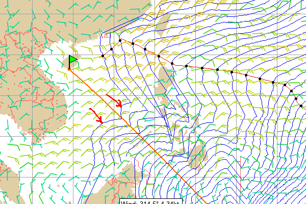
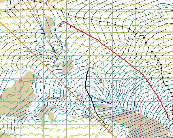
What the hell is going on with the Gribs and the interpolation?

I understand a major switch between ine and 2 Gribs, not that usual, but in unstable places it's more common. However, I would say that a forecast about a depression is more accurate than the weather generally happening in the areas we are navigating. So it is a bit strange, the big jump.

But not even close to the strange it is to have 2 major weather forecast switches during interpolations maps.

And there are not mere close alternatives that even the router is floating from one to another is one that goes radically to another. Like this it's impossible to design a strategy. We are going in zig zags. Unsuspected good skippers are doing 360's, others' are stopped almost in a zero twa. It seems the solution, It's just go with the flow...not funny, just a lottery. That's not a race.

Better put the boat with fix heading to buoy and in 3 days come and adjust...

And I swear it's not paranoia but this together with, rankings in main game UI not updating, suddenlly dozens of boats unnecessary boats showing up in satellite view (meaning that some tweaks were made), difficulties in clicking some boats to update their positions, file that updates dashboard ranking and DTL messed up...this is smelling like VR is out of control again.

Or a torpedo...

or..it's me...seeing ghosts..and the weather is good...and i'm just dreaming

Post by iconPost by nsp | 2018-01-30 | 15:57:30
One more big change in the weather one hour and a half roughly after new Grib :(
Post by iconPost by zezo | 2018-01-30 | 16:01:25
It will be like that for a while. The change may be abrupt or gradual and the router may be in sync with the game or not, but the change is still there in the original data.
Post by iconPost by jacenty67 | 2018-02-04 | 14:04:19
Today's difference in wind directions - up to 30 degrees ...
Is it VR or zezo fault?

Post by iconPost by Ursus Maritimus | 2018-02-04 | 17:14:34
with big windshifts there will always be a difference during changeover:
Zezo is phasing in the new grib gradually and so is VR. The method however is different and sometimes this will lead to big differences during zezo updates (see post: http://zezo.org/forum.pl?tid=6109)
Post by iconPost by Trailaspress | 2018-02-12 | 19:38:39
Wow nice end for the leaders.
Post by iconPost by user1234 | 2018-02-12 | 21:41:40
stupid game interface

tessa's track on my screen

https://imgur.com/a/Q56pF


Hmm, probably everyone should use the vr dashboard if the game messes even the tracks like this. Wonder how much it "lies" about more important things like wind speed and direction etc. Easy to try and set your boat driving optimum angels, when you really can't know your exact wind angels etc..


Post by iconPost by user1234 | 2018-02-12 | 21:44:33


INGNORE / remove

(im useless with computers :D)


border
Topics list
Posts
border
5
border
border
Copyright 2009 by ZEZO.ORG. All Rights Reserved.